
Dig
This! Erosion Investigation
Stories of Erosion
|
|
Dig
This! Erosion Investigation |
|
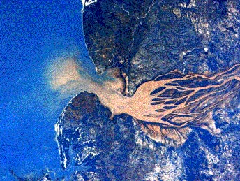
Deforestation
Leads to Sedimentation and More: Madagascar Island
Source: NASA's Earth Science Enterprise Informational CD-ROM Version Human-Induced
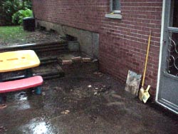
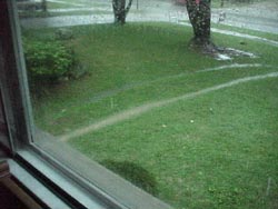
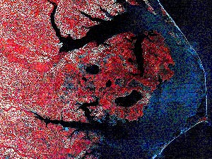
Wind Erosion and More: The Aral Sea Reduced water flow, coupled with evaporation, has had three primary effects: first, the remaining water has become extremely salinized; second, the moderating effect of the Aral Sea on local climate has diminished, resulting in hotter summers, colder winters, and a decreased growing season; third, over 20,000 square kilometers of land that were once submerged now are exposed. Dust storms raise up massive amounts of salt from the exposed sea bed and move it hundreds of kilometers away, depositing on surrounding land and reducing crop production. If this process continues at the same rate, the Aral Sea will cease to exist by the year 2020. Click here to view two images from NASA's Landsat Multi Spectral Scanner (MSS). Source: NASA's Earth Science Enterprise Informational CD-ROM Version 3 What Comes Around Goes Around: Cincinnati, OH Around the completion of this online investigation, a severe thunderstorm blew through my community. Due to a combination of our dog's desire to dig and drought conditions, our yard was ripe for erosion. These pictures show the area where the erosion originated and the sediment that was carried around the house and out to the storm sewer. Perhaps I should call on the Wilmington Middle School students to solve my erosion problem! John Farmer Topography Source: NASA's Earth Science Enterprise Informational CD-ROM Version 3 Coastal
Changes Which Lead to Erosion and More Sea level rise caused by global warming will have pronounced impacts on coastal areas by causing submergence of low-lying areas and loss of wetlands, as well as erosion of beaches. Unfortunately, many of the buildings and facilities humans have built along the coasts are not adequately above existing water levels or located far enough inland to ensure survival and safety of residents during storms. This hazard is becoming increasingly apparent as relative sea levels have risen throughout the twentieth century. Click here to view and Earth Observation System (EOS) image which highlights coastal change. Source: NASA's Earth Science Enterprise Informational CD-ROM Version 3 Erosion
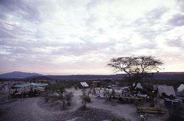
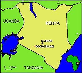
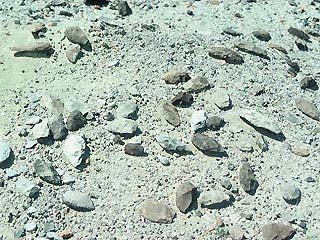
Helpful to Anthropologists Fortunately for these anthropologists, recent erosion has exposed a jumble of stone tools left by our ancestors, buried by the sediments of a local stream channel nearly 900,000 years ago, and then re-exposed to the elements by recent erosion. These areas of erosion allowed them to find the actual layer of burial in a nearby hillside. At that point careful excavation can occur. By careful study of the position of the objects and any evidence of edge rounding, the excavated tools may help answer whether or not they were originally deposited on the spot by early people or carried here through sedimentation by flowing water from some other place the toolmakers lived. Only by doing this painstaking record-keeping can they figure out whether this particular place was visited by the Stone-Age toolmakers many times, only once...or never at all. Source: The Smithsonian Olorgesailie Prehistoric Site website |